Traveling through the Mountains

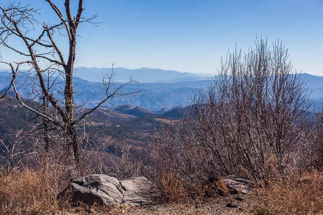
Coronado Trail in the White Mountains

Coronado Trail in the White Mountains ©2012 Bo Mackison

“A traveler without observation is a bird without wings.”  ~ Moslil Eddin Saadi      

Day 3. More notes from my travel log.

We leave Albuquerque. It is 5:55 am and it’s a bit chilly – 45˚F. It is still dark, though there is the barest hint of light in the eastern sky.

We begin by traveling south on Interstate 25, but after 80 miles, we choose a scenic route on a state highway. The trip will be a few hours longer but more interesting. I have a hard time resisting a 120 mile scenic drive through mountains!

As soon as we turn off the busy interstate, I find myself breathing more deeply, my eyes become clearer and I can see further. I feel calmer driving on the less traveled roads, seeing the locals and an occasional traveler, stopping frequently to take a few photographs.

We climb in elevation as we approach the White Mountains. It is still early morning, still cool and getting colder. As we drive near the Magdalena Mountains – highest peak is South Baldy at 10,783′ – we are at 6700′ and the temperature has dropped to 23˚. Sky islands!

We keep seeing signs for “VLA” – not sure what that means. Finally we come to a high plains that has a Very Large Array of radio satellite dishes. I feel like we are traveling on the moon!

We pass Historic Hoof Highway – a trail developed in 1885. It once connected Springerville, Arizona, to Magdalena, New Mexico, a distance of 130 miles. There were supplies and a well every ten miles – a rather adventurous plan – but thousands of livestock passed those miles in good health because of the Hoof Highway.

Not only are there junipers and cedars now, there are Ponderosa pines. Telephone pole pines.

I wonder if there is a hand-held device that tells the altitude? I’m often curious about the altitude when I travel, especially when I’m hiking up and down mountain trails.

We drive across the Continental Divide.

Pie Town, New Mexico
Cross the New Mexico/Arizona border at 10:21 am.
Coyote Wash (dry)

Escadillo Mountain, the highest peak is 10,992′. First snow we have seen covers its peak.
Springerville, AZ, founded in 1870, elevation 6973′. Last chance for gas for 120 miles.

We turn south and drive 120 miles on the Coronado Trail, from Springerville to Clifton. It is a road that thinks it is a roller coaster.

Roosevelt Lake
Nutrioso Creek (water)
Cambell Blue Wash (water)
Hannagan Creek (water)

We begin in the high plains, drive for several hours through the White Mountains and finally reach the Chihuahuan Desert. From Ponderosa pine and sycamores dressed in their autumn yellow to prickly pear, barrel cacti and ocotillo in a few hours.

Eagle River (dry)
San Simon River (dry)

There are cotton fields in Safford – elevation 2920′. Some is already picked and wrapped in huge rolls, ready for truck hauling. Other fields are have dark plants half white with fluff of cotton.

We turn on I-10 — now it’s a straight shot across half the state to the Tucson area.

Stockton Wash (dry)
Adams Peak Wash (dry)
San Pedro River (dry)
Cienega Creek (dry)

We turn off the interstate at Sahuarita. It is 4:05. Sunny and warm. 80˚F.

The pecan trees in the orchards are still green, though a few of their leaves are yellowing.

In another 10 minutes we are at our destination. We walk the neighborhood, watch the sun set behind the mountain ridge, finally unpack the car.

We traveled 1963 miles over 4 days. (First leg of the trip was on the Wednesday before Thanksgiving, when we drove 300 miles straight south to celebrate with the family before leaving for the Southwest.)

It is 81˚F.

I am back home in the desert!

~~~~~~~~~~~~

Bo Mackison is a photographer and the owner of Seeded Earth Studio LLC.  Happy! Home!
Bad Luck to Steal Saints

Bad Luck to Steal Saints

Bad Luck to Steal Saints ©2012Bo Mackison

Retabaleros. These are versions of dozens of Catholic saints painted in the classical style on Masonite. This store in Old Town Albuquerque had a large display of these little plaques, and as an added bonus offered a friendly warning– bad luck to steal — especially the saints. ~ Bo Mackison

Day 2. A short day of travel. Yay!

While we have traveled through Albuquerque, even spent the night there a couple of times, usually we are in a hurry to get to our final destination. This trip we made an extra effort to plan some visiting time in Albuquerque.

We left Tucumcari, New Mexico at 6:40 am. Our destination is the Hotel Parque Central in central Albuquerque, a renovated hospital turned hotel, and an awesome place to visit.

Mesas are most beautiful when the early morning sun casts golden highlights upon them. The beginning of what I all the high desert. No large cacti. Lots of sage brush, prickly pears.

We watch the shadow of our car travel along the side – our car on the road, the shadow of our car “driving” on the access road. Lots of laughs.

Gas is $3.39 a gallon for regular. Only once did we see the price dip under three dollars. (Always cheapest in the Kansas City area!)

Now cedars and junipers dot the desert scrub. Little balls of tight green foliage. There is more brittle bush, cholla, yucca.

This is the beginning of the land that tunes my soul, makes my heart sing. I have a heart connection with the Southwest.

Blanco Creek (dry)
Pecos River (dry)

Western Kansas, Oklahoma and Texas — to me, they all look like “the west.” New Mexico feels like “out west.” Is there a difference? I wonder?

We pass the Sangre de Cristo Mountains and the city of Albuquerque spreads out in front of us. It is 9:22 am when we pull into the hotel’s parking lot.

We play tourist much of the day. Visit Old Town Albuquerque (where I took the above photo) and wander through stores and art galleries. In the afternoon, we hike the trails at the Petroglyph National Monument on the western side of Albuquerque. We walk the bosque along the Rio Grande for some late afternoon exercise. Then have dinner with a blogging friend who has become a real life friend. How sweet is that!

—————————

Bo Mackison is a photographer and the owner of Seeded Earth Studio LLC. One more day of travel before Bo once again sees the Sonoran Desert!

Not Your Ordinary Travel Journal

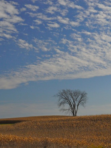
Solitary Tree

Solitary Tree in Iowa © 2008 Bo Mackison

As we drove the roads guiding us westward earlier this fall, I scribbled thoughts into my journal as they passed fleetingly through my mind. I’m sometimes fascinated, and a little disconcerted, at what I choose to document for future consideration. Here is a sampling of the notes from the beginning of the trip, as we began in Wisconsin and headed west towards Denver.

“West of Des Moines the country grows drier, though surprising to me, it has a distinct roly-poly-ness, rather like a split-second capture of grassy waves.”

There is a Las Vegas in Nebraska. Now what would the Spanish translation be for las vegas?” (I later Google the word and find it means “the meadows” – understandable, I suppose, in Nebraska, but does the Las Vegas in Nevada really have meadows?)

“Thirty miles west of Des Moines, the land suddenly flattens, the plains appear and seem to be infinite. I-80 narrows, in anticipation of less traffic. Suddenly it feels really out west.”

“I’m hungry. What I’d really like is a toasted pimento cheese sandwich. Craving a toasted pimento cheese sandwich. Really craving!”

“There is a town in Nebraska called Republican City. I wonder how many people living there are Democrats.” (Research tells me it is the only so named city in the world, named for the Republican River, not the Republican Party, but I haven’t been able to determine the percentage of citizens who are registered Republicans versus Democrats.)

There are sandhills in western Nebraska. I didn’t know there were sandhills here. Is there sandhill country like this in other places in the United States? In the world?” (Again, later that day I Google sandhills. I rely on the source of all sources, Wikipedia, to inform me that there are sandhill regions not only in Nebraska, but also in the Carolinas. I learn the Nebraska sandhills are the largest and most intricate wetland ecosystem in the United States, and never having been farmed, it is an intact eco-system with huge diversity. Wow! Way to go, Nebraska! Apparently the less fortunate Carolinas’ sandhills have been domesticated, and seem most famous for their golf courses.

“Came upon the first of many cattle feedlots as we approach the Colorado border. Horrifying. How can this be tolerated?”

“Such noticeable changes as we pass through the states – in Wisconsin and Iowa there were prairie wildflowers growing on the roadsides. In Nebraska, lots of tall, brown dried grasses. Now that we are in Colorado, there is a mix of sagebrush interspersed with the clumps of grasses.”

Such were my musings from Wisconsin through Iowa and Nebraska and finally into Colorado.

It re-affirms my daily task of journaling. These aren’t the kinds of things I would easily recall, nothing very noteworthy, but they add a little more dimension to the trip. They give me the opportunity to research and follow up on questions I might otherwise leave unanswered. And who knows what kind of inspiration they may provide in the future. Never can tell what kind of inspiration I may draw from a toasted pimento cheese sandwich!