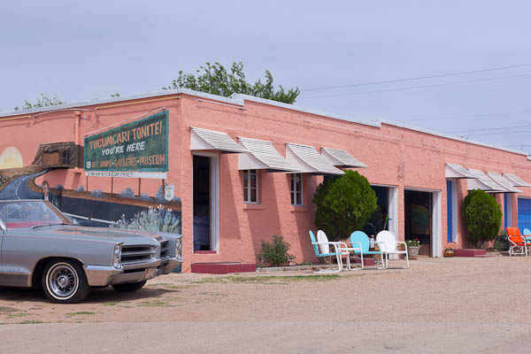
Purchase Tramadol Overnight Tucumcari Tonite ©2012 Bo Mackison
https://www.merlinsilk.com/neologism/ The world is a country which nobody ever yet knew by description; one must travel through it one’s self to be acquainted with it. ~ Lord Chesterfield
Day 1 Part 2. The travel notes continue:
We note the differences between Iowa/Illinois and Missouri. Missouri has fewer corn fields. It looks scrubbier, homes are smaller. The land is undulating, like Iowa – gentle hills, lots of stands of old trees, mostly oaks. There are more horses, fewer cattle and no dairy farms. The barns are used less for protection of animals, more for storage of grains. They are open and often have several lean-to sheds propped against their exterior walls.
Passing Hamilton MO, boyhood home of J C Penney. Hmmm.
Sunlight streams though the stand of oak, all is a rich golden brown in the low sunlight. They look like shimmering cinnamon sticks.
Cameron MO. Gas is $3.07. We finally get on an interstate to make faster time. I-35.
Passing ENCHANTED FROG ANTIQUES. Looked interesting, but not open. Wonder how it got its name?
First time we see gas for less than three dollars a gallon. $2.99 at Exit 40. Why is gas always cheapest around Kansas City area? — we notice this every time we pass through.
Head into Kansas City, MO at 8 am.
Crossing the Missouri River – managed a few photos of the overhead structure of the bridge. The HISTORIC IMPERIAL BREWERY BUILDING is for sale. It has style, bet it was a real beauty, back in its heyday.
Fishing Creek
Turkey Creek
Missouri River
Kansas state line. 34 degrees and sunny as we leave Kansas City, KS. 8:30 am.
Entering the Flint Hills of Kansas. There is a National Geographic spread — 22 pages – on the Flint Hills in its April 07 issue. So the sign says.
Bull Creek
Wolf Creek
Ottawa Creek
Marias de Cinega
Tequa Creek
Kansas compared to western Missouri? Flatter lands, still shrubby. Farms have fewer barns and store more of their equipment and larger household appliances outside. Oil wells – the ones that stand about 8 feet tall – pump in many fields.
Speed limit has gradually increased from 55 in Wisconsin to 65 in Iowa to 70 in Missouri and now it is 75 mph.
The woods are oak, hickory, sycamore. Only an occasional evergreen tree or shrub.
Rock Creek
Coal Creek
Long Creek
Frog Creek
Badger Creek
Why is Marion, KS called the Rhino Capitol of the World?
Stopped at the Tall Grass Prairie National Wildlife Refuge. There is a nearby bed and breakfast, CLOVER CLIFF RANCH. I would like to stay here for a few nights. What a great setting, looks like a great ranch!
Long trains are now frequent. Freight cars pulled and pushed by 4 to 6 engines.
Landscape is mostly grasslands. Fewer stands of trees. Most of the trees we see were planted for windbreaks around ranches and farms.
Emporia KS is the Founding City of Veterans Day. It is a good place for historic buildings, too. Historic district.
Past Emporia, the tenor of the land is drier, colorless. Many shades of brown, but the rich soil is a deep black. The landscape is offset only by a pale blue sky. Most of the land is for grazing. The buildings are built close to the ground – earth huggers – a good idea in this tornado and blizzard belt.
There is an underground salt mine in Hutchinson KS. Hutchinson is called the “Salt City.” It also has a rescue/adoption program for wild mustangs. Gas is $3.21.
Cow Creek
Ninnescah River
Arkansas River
Only scattered farms. Lots of solitude to be found in western Kansas. Still very dry.
Crooked Creek (dry)
Cimarron Creek (dry)
Pony River (dry)
Beaver River (dry)
Now we are in Oklahoma, crossing just a snippet of its Panhandle. It looks like southwestern Kansas – not a surprise. There is sage brush, dried grasses. And the feed lots – which always make me fret over my decision not to be a strict vegetarian.
Now we are in Texas. We are crossing a bit of this state’s Panhandle, too. Gas is $3.27 a gallon in Dalhart, Texas.
We arrive in Tucumcari and find a hotel, order carry-out for supper. It is 5:45 pm.
On out first travel day, designed to be long on driving while we are both fresh, we traveled 14 hours and drove 863 miles.
Tomorrow we arrive in Albuquerque early, and take time off for exploring, before the last leg of our journey.
——————
Bo Mackison is a photographer and the owner of Seeded Earth Studio LLC. She loves to document facts and trivia in her travel journals when traveling cross country.


Sitting here reading thru your travel notes and adventures. Love it!! Thanks for taking me along for the journey!
You are more than welcome to come along on my travels, Marcie. Bet you’d find a million things to photograph, too!
quite the drive. i enjoyed the litany of rivers and creeks so far.
There are such amusing names for the many waterways. It’s a fun thing to watch for…
Absolutely fascinating. My step mom is from Kansas. My dad once told me the Kansas State Tree is the telephone pole – he’s quite a character, my dad. I am just lapping up this travel log stuff….OH! And I LOVE LOVE LOVE this photo!
That is soooo funny. Kansas tree is the telephone pole — oh, so true, too!